Request a Demo

eSteering

Real-Time Geosteering Software

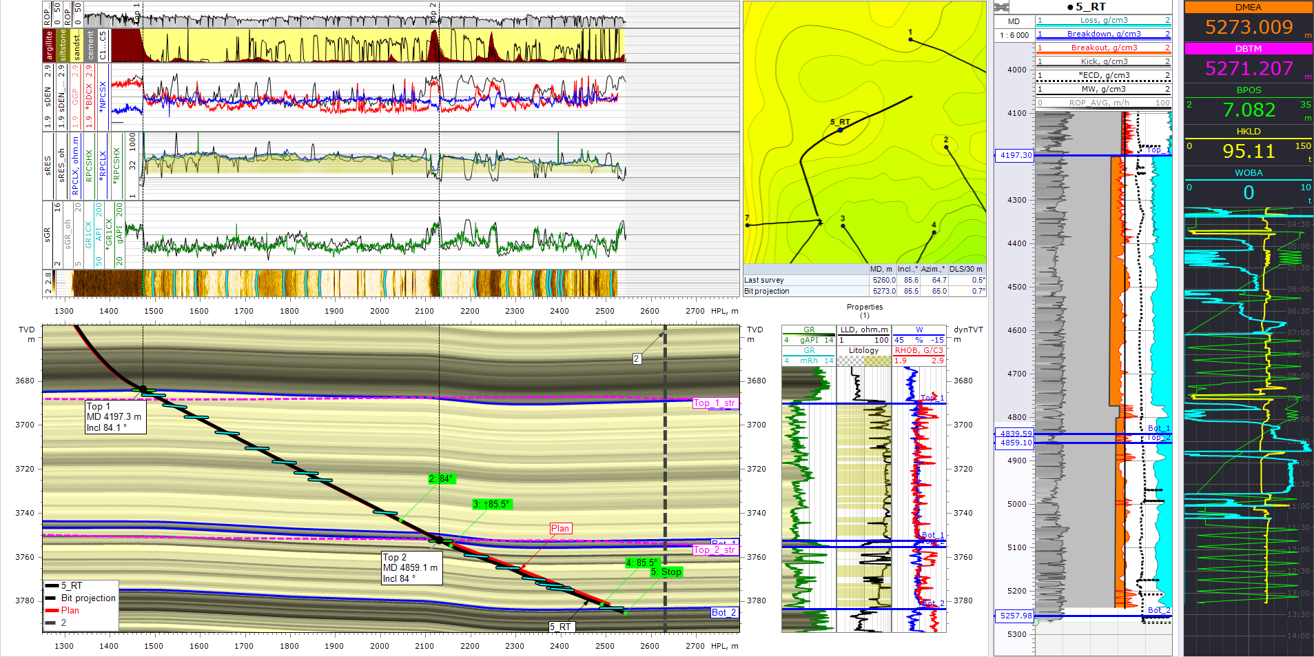
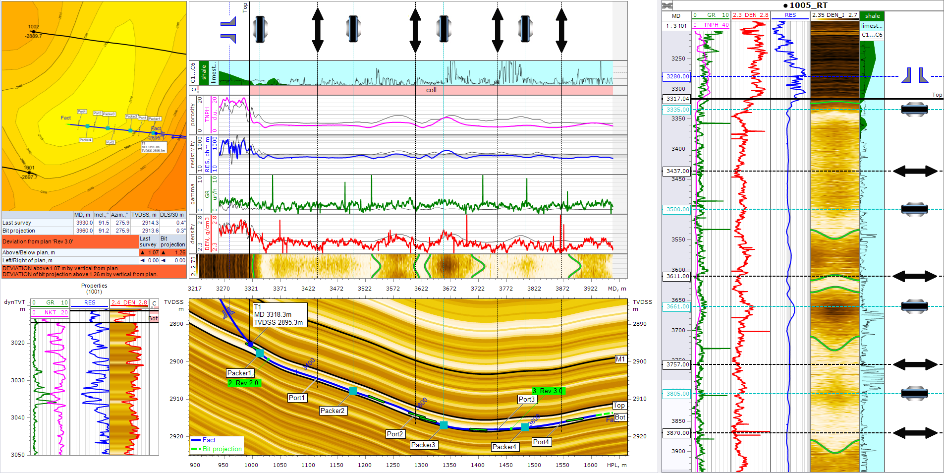
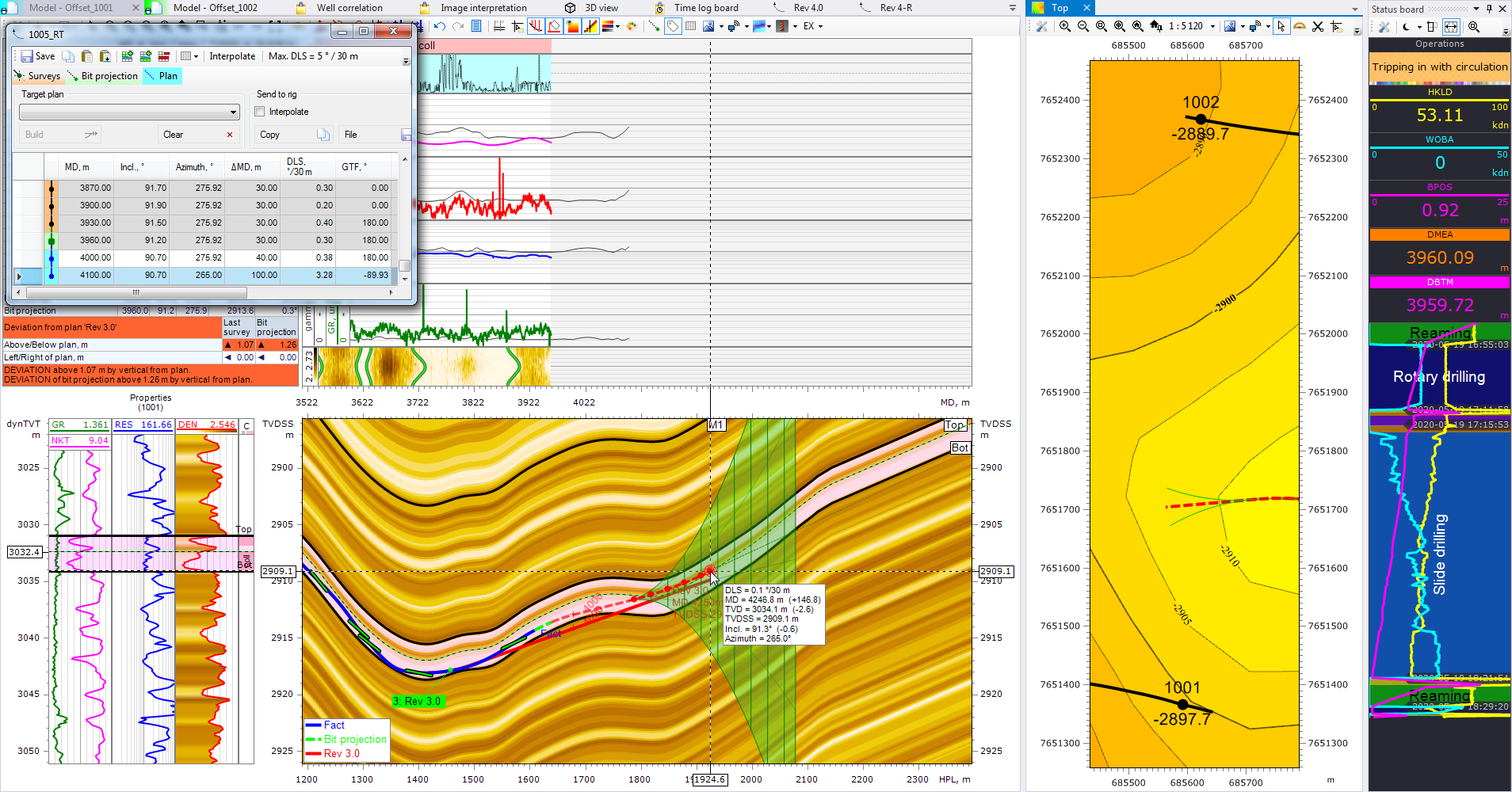
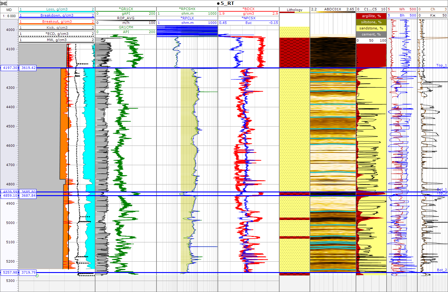
eSteering is a cutting-edge geosteering software designed for drilling, offering advanced engineering tools in a desktop environment. Its functionality extends to real-time operations through a WITSML connection, as well as offline use in remote locations. The software is equipped to simulate diverse geologic conditions by integrating LWD/MWD data, mud-logging data, seismic sections, and Geomechanical data. Boasting logical and practical features, eSteering includes a unique set of tools that ensure precise well placement and optimal positioning within the reservoir.

eSteering Advantage

  • Increased Precision: Enhance the accuracy of well placement by providing real-time data and analysis, optimizing the drilling path for better reservoir contact.
  • Cost Efficiency: Improve accuracy in well placement minimizes unnecessary drilling and reduces operational costs, ensuring resources are utilized efficiently.
  • Enhanced Reservoir Recovery: Geo-steering allows drilling teams to navigate through optimal reservoir zones, maximizing hydrocarbon recovery and overall reservoir performance.
  • Risk Mitigation: Identify potential drilling challenges and geological uncertainties in advance, enabling proactive measures to mitigate risks and avoid costly complications.
  • Optimized Wellbore Trajectory: eSteering assists in maintaining the desired wellbore trajectory, ensuring alignment with geological targets and minimizing the risk of deviation.
  • Data Integration: Integrate various data sources, such as LWD, mudlogging, and 3D geological models, providing a comprehensive view for informed decision-making.
  • Improved Collaboration: Enhance communication and collaboration among drilling, geology, and engineering teams, fostering a more integrated approach to well planning and execution.
  • Geological Model Integration: Seamless integration with 3D geological models, enabling the use of imported structures for accurate geosteering and better alignment with geological formations.
  • Post-Drilling Analysis: Provide valuable post-drilling analysis, allowing companies to assess the success of drilling campaigns, identify areas for improvement, and refine future drilling strategies.
  • Automation and Customization of Reports: Powerful report generator, FastReport, enabling automatic report generation according to preset templates and export in various formats allowing for flexible customization of reports and email automation from project components.

eSteering Features:

  • Interactive reconstruction of synthetic well logs adjusting surface geometry with mouse movement enabling you to make faster and more accurate selection of desired parameters (bed angle, verticality, thickness) 
  • Auto-save data automatically saves all downloaded information and project changes to prevent data loss during drilling 
  • Universal data import module provides effortless import of well trajectory, mud logs, and other data in various formats without pre-formating 
  • Full well correlation panel for displaying, formatting and comparing wells
  • Ability to download WITSML data in real-time from multiple servers simultaneously without limits
  • Azimuthal data module calculates formation angles digitally, relative to the drilled borehole or in absolute values 
  • Automatic calculation of petrophysical and technological parameters using LWD and mudlogging data in real-time.
  • Time-Based Dashboard for tracking operational parameters.
  • Model and Stratigraphic Geosteering method projects horizontal well data directly onto offset wells, with a classical method considering formation structure geometry to generate synthetic well logs.
  • Geosteering from multiple offset wells for reservoirs with lateral variability eSteering recommends creating geosteering models from multiple offset wells closest to specific sections of the horizontal wellbore and offers the option to use a section of the actual well as an offset well if drilling from top to bottom.
  • Manage geological structural surfaces in 3D module.
  • Offset Well Trajectories on the Section

    Enhance Geosteering accuracy by integrating trajectories from nearby wells, including critical formation tops, into your analysis.
  • Well Masterlog

    Track essential well objects such as packers, casing shoes, and coring tools with the Well Masterlog feature, ensuring thorough monitoring and management of the wellbore.
  • Building a Plan Using Azimuth

    Verify the alignment of your well trajectory using azimuthal images and the powerful eStream tool for dip picking, enabling conversion into Geosteering scenarios encompassing dips, 3D formation angles, and formation dip tables.
  • Pattern Integration

    Enhance results by leveraging comprehensive data, including cuttings descriptions and interpreted geology, to correlate multiple parameters and refine Geosteering strategies effectively.

Offset Well Trajectories on the Section

Enhance Geosteering accuracy by integrating trajectories from nearby wells, including critical formation tops, into your analysis.

Well Masterlog

General well information including well location and weather conditions at the well site.

Trajectory

List of plan revisions, possibility to create & interpolate well trajectories, including complicated multi-borehole well profiles.

Pattern Integration

Enhance results by leveraging comprehensive data, including cuttings descriptions and interpreted geology, to correlate multiple parameters and refine Geosteering strategies effectively.

Download eSteering Full Spec Sheet

Office

Suite 2500, 500 4th Avenue South West Altius Centre
Calgary, AB, Canada
T2P 2V6
Send A Message
+1.403.899.3338
Adaga Solutions © 2024. All Rights Reserved.
linkedin facebook pinterest youtube rss twitter instagram facebook-blank rss-blank linkedin-blank pinterest youtube twitter instagram